|
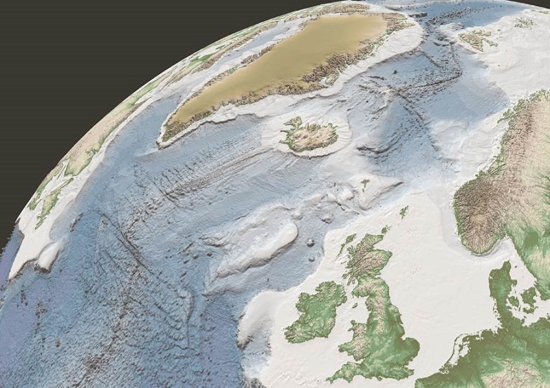
From Castlebar - County Mayo - Tech Corner A geological atlas - the Northeast Atlantic Geoscience Tectonostratigraphic Atlas (NAGTEC) - has just been launched that details what lies beneath the Northeast Atlantic Ocean. Ireland's territory off the west coast extends out into the Atlantic. The information contained in the atlas can help us to understand details of the rocks, what they are composed of and how they have changed over time. Increasing knowledge Geologist Maria Judge, who works at the Geological Survey of Ireland, was the Irish project coordinator for the new atlas. "It's exciting to be discovering parts of our nation and learning its secrets, which may benefit the oil and gas exploration industry...and also facilities marine and geological research," she says.
According to Judge, the aim of the three-year project was to compile all available data over the entire Northeast Atlantic region into one atlas. "We can learn what processes took place over this vast area in the last 200 million years, which ultimately resulted in the formation of offshore basins and the Atlantic Ocean as we know it today," she explains. Irish involvement The atlas is made up of data that already existed. The data was brought together and reanalysed to create "modern sciences best attempt so far" to understand the dimensions of the Atlantic Ocean. Judge worked on the project with a number of scientists from University College Dublin, as well as with partners across Europe. "We shared our experience, knowledge and data equally," she adds. So why is this important? Judge believes it will result in more research on Irish data and could lead to increased exploration offshore. There are a small number of companies exploring offshore Ireland at the moment. "This atlas could be used by interested companies to help identify potential sites for exploration," she says. Informing debate Offshore drilling is when the seabed is drilled to explore if oil or gas is present and to extract any that lies under the ocean. This has been the cause of recent debate in the United States following the explosion of a drilling rig in the Gulf of Mexico which triggered the largest offshore oil spill in the country's history. There has been some opposition to offshore drilling in Ireland but Judge says the new atlas "helps us understand our Irish margin better and supports research". Our Irish margin refers to Ireland's section of the Atlantic margin, which is an area of the Atlantic Ocean where the continental plate which Ireland sits on meets the oceanic plate beneath the Atlantic Ocean. Oil reservoirs are often found in these areas. The Irish Government are currently accepting licensing options from oil companies for our section of the Atlantic margin. For those against the "development of our own natural resources", the geologist believes the atlas allows for informed debate and enables realistic comparisons between Ireland and other countries. Much of what lies beneath the ocean still remains a mystery, but projects such as this are increasing our knowledge of our offshore landscape and how it was formed. Science Foundation Ireland Science Week © Copyright 2014 by Castlebar - County Mayo - |