 |  |
Posted by Murrisk on November 13, 2001 at 12:47:06:
| |
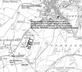
At or shortly after St. Mary's was built in the late 1800's the river connecting Saleen Lake to Lough Lannagh was deepened to improve drainage (see the atached mhriver.jpg). At the same time quarries, now filled in, were developed to feed the lime kiln on what was known as the Mental Hospital farm. Cattle grazed, crops were grown and the patients were took exercise by walking the central rectangular area supervised bt attendants (nurses). All of the farm work was done by patients the majority of whom came from farming backgrounds. The quarries and the lime kiln were still active in the 1960's. The quick lime was stored in a shed beside the river near the sewage tanks (where the traveller's stopping park is located). The lime was applied to acid soil and small amounts were used in white wash. The Mental Hospital farm is now a pitch and putt club. Around the same time as the Mental Hospital river was deepened a weir was built on the river where it flows into Lough Lannagh.
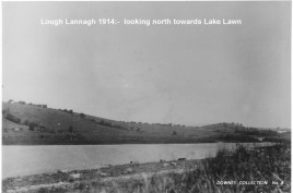
There were widespread drainage schemes in the late 1880's/1890's. The level of Lough Lannagh was lowered and it was at this time that Lough Lea was drained. The attached photo (lake1914.jpg) taken in 1914 shows the lowered lake level with cattle grazing. The photo is looking towards Lake Lawn (Newtown/Marsh House). The white house in the photo might be the then newly built St. Mary's Presbytery which was/is on high ground directly opposite the newly built church or perhaps Marsh House ??
Prior to drainage, the Castlebar river where it exited Lough Lannagh was wide with an island in it (see Murrisk's earlier postings of Castlebar in 1839 and 1870). The island disappeared with the drainage. The extent to which the level of Lough Lannagh was lowered can be gauged by comparing the outline of the lake in 1839 and 1917. In 1839 the five Boyd's Islands (later to be known as McDonald's island) were surrounded by water. In 1917 they were part of the shoreline.
In 1839 there was a small island (6 perches) in the lake opposite the graveyard. In 1917 this island does not appear on the map. Some may remember tales of a 'floating island' in the lake - people from the Newport Road used to tie their boats to it. It did not survive the Moy drainage of the 1960's. There was speculation that it might have been a crann¾g but I don't think so. I think the 'floating island' was the remnant of this small island.
Click on the above photos to enlarge